


Petrix Maps Oilfield Navigator
Epitosoft
When I first looked at Petrix Maps Oilfield Navigator, I understood its appeal quickly: it is built around one practical job rather than trying to become a general-purpose business suite. The app focuses on helping users navigate to US wellsites, oilfields, and rigs, which makes it much more relevant to field work than an ordinary road map. In my experience, that narrow purpose is also its biggest strength. If your day involves finding petroleum locations, a map designed around that task can save more time than a familiar consumer navigation app filled with unrelated places.
Petrix Maps Oilfield Navigator is a free business app from Epitosoft, with optional in-app items priced from $14.99 to $19.99 each. It is suitable for Everyone, runs on Android versions from 6.0 onward, and has reached over 50 thousand installs. Its average score is 4.2 from roughly 250 ratings, with close to 90 written reviews, so it has a useful amount of public feedback without being one of the enormous mainstream mapping services.
Finding oilfield locations is the central idea
The important capability here is not simply displaying a map. It is the attempt to make oilfield navigation the starting point of the experience. A normal map application expects you to search for a street address, business, or recognizable landmark. That approach can be awkward when your destination is a wellsite or rig in a remote area, where a conventional address may be less useful than a location associated with a field or well.
That difference changes how I think about the app. I would not install it as a replacement for every map on my phone. I would use it as a specialist reference when the destination itself belongs to the oil and gas landscape. The value comes from reducing the gap between “I need to reach this petroleum location” and “I can identify the correct place on a map.”
The strongest reason to try Petrix Maps is its specialized destination focus, not general navigation convenience. That distinction matters because a specialist tool can be worthwhile even when it does not offer the broadest collection of everyday map features. A delivery driver looking for restaurants would gain little from it, while a contractor visiting several wellsites could find the narrower design much more appropriate.
Related News

Why WhatsApp Messenger Still Makes Everyday Communication Feel Easy

Jurassic World: The Game Is the Better Dino Tycoon for Strategic Players

Threads in Real Life: Who Should Join, Lurk, or Leave

How SHEIN Turned Shopping Into an Endless Content Feed

How to Make Fortnite Feel Smarter on Mobile

Should You Switch to Microsoft Outlook on Mobile?
The app’s store short description is simply “Petrix Maps,” but the fuller purpose is clearer in use: this is a location tool for US oilfield work. That geographic focus is important. Someone working outside the United States should not assume that the app’s main value transfers automatically to another country. The more closely your assignments match US wells, fields, and rigs, the more sense the app makes.
Why a specialist map can beat a familiar alternative
General mapping apps are excellent for public roads, businesses, traffic, and ordinary addresses. They are usually the first choice for driving directions, and I would still keep one available for the final road journey. Their weakness is that they are designed for the majority of travelers, not for people whose destinations may be scattered across producing areas or identified through industry-specific location information.
Petrix Maps occupies a different place in that workflow. Instead of asking a broad map to understand an oilfield task, I can begin with the oilfield task itself. That can make planning less frustrating, particularly when several nearby locations have similar names or when the destination is not the kind of place a consumer map emphasizes.
Gallery
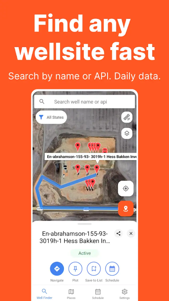
There is a trade-off, though. A specialist map is only better when its specialist information matches the user’s needs. If I am mainly looking for live traffic, restaurant stops, street-level guidance, or a polished turn-by-turn driving experience, a mainstream navigation app is likely the better companion. Petrix Maps should be viewed as a focused layer in a field-work toolkit, not as an automatic replacement for every other map.
What using it feels like in a real workday
Imagine a technician who receives an assignment in the morning and needs to visit more than one location in a producing area. The first task is not necessarily to drive immediately. It is to understand where the relevant wellsite or rig sits in relation to the roads, nearby communities, and the other destinations on the schedule. This is where I would open Petrix Maps first: to identify the work locations and build a sensible mental picture of the day.
After that initial check, I would use the specialist map to compare the positions of the sites, then move to a familiar road-navigation tool if I wanted conventional driving instructions. That two-step workflow is more realistic than expecting one app to do everything equally well. Petrix Maps helps answer “where is the industry location?” while a general navigator may be stronger at answering “which road should I take right now?”
A useful habit is to review the destination before leaving an area with reliable connectivity. Remote work can expose the weakness of depending on a single screen at the last moment. I would make a note of the location name and surrounding road context, check the route in my usual navigation app, and avoid treating the specialist map as a substitute for basic trip preparation. This is not a criticism of Petrix Maps alone; it is sensible practice whenever the destination is rural or unfamiliar.
Another practical tip is to use the app for grouping visits rather than opening it only after getting lost. If three assignments are in the same general oilfield area, looking at them together can help reveal whether the order of visits is sensible. Even without turning the app into a complete dispatch system, that visual overview can prevent unnecessary backtracking. The benefit is less about a dramatic feature and more about using the map before the engine starts.
A realistic scenario for contractors and service crews
Consider a small service crew sent to inspect equipment at a remote rig. The crew leader may already have destination details from a client, but those details still need to become a workable journey. I would use Petrix Maps to orient the destination within the relevant oilfield context, confirm that I am looking at the intended location, and compare it with nearby assignments. Then I would switch to the road tool I trust for driving instructions and keep the specialist map available for checking the broader field layout.
This approach is especially useful when the crew has a changing schedule. If a second job is added nearby, the app’s specialized view can help the team think in terms of field locations rather than unrelated map pins scattered among businesses and public landmarks. It does not remove the need to verify instructions from the customer or site operator, but it gives the crew a more relevant visual starting point.
For a land professional, lease worker, inspector, or equipment supplier, the same pattern applies. The app can be most valuable during preparation, when location awareness matters more than polished consumer navigation. I would not rely on any map alone for access rights, road conditions, gate arrangements, or current site status. Those details can change independently of the map, and responsible field planning still requires confirmation from the people managing the location.
Where the app earns its place
The app’s best scenario is a user who repeatedly works with US oilfield destinations and needs a dedicated way to think about wells, fields, and rigs. Repetition is important here. If I visit one remote site once, downloading a specialist app may not be worthwhile. If I regularly receive assignments involving petroleum locations, the focused map becomes easier to justify because it supports the same type of decision again and again.
It can also help users who are new to a particular producing region. A general map may show the roads, but a specialist oilfield view can make the industry geography easier to understand. That is useful for planning a day, explaining a destination to a colleague, or checking whether several jobs are clustered together. In my view, this orientation role is more convincing than the idea of using the app as a standalone navigation replacement.
There is a quieter benefit for office-based staff, too. Dispatchers, coordinators, and managers may need to discuss field locations without being physically present. A map centered on wells and oilfields gives those conversations a more suitable reference point than a consumer map designed around shops and public attractions. It can support clearer planning discussions, especially when the work involves multiple destinations across a large area.
One non-obvious trade-off is that specialized information can make a map more useful for one decision while making it less convenient for another. The same screen that helps me understand the oilfield context may not be the fastest way to find fuel, food, lodging, or a hardware store. I would keep a general map installed and switch between the two deliberately instead of expecting Petrix Maps to cover those everyday needs.
How to get more from the focused design
I would begin each trip by separating three questions: which location is the work destination, how does it relate to the surrounding field, and what is the safest practical road approach? Petrix Maps is most relevant to the first two. A road navigator, local contact, or company procedure may be more important for the third. Keeping those questions separate reduces the risk of assuming that a map marker automatically tells me everything I need to know about access.
For multi-stop work, I would also record the order of locations outside the app if the day is operationally important. A specialist map can help with visual planning, but a written itinerary or company dispatch system remains useful for names, contacts, appointment windows, and site instructions. This is a realistic limitation: a location-focused app can improve geographic understanding without replacing the administrative side of field service.
Another useful habit is to compare the map view with information supplied by the job coordinator. If the location name, field name, or destination description does not line up, I would pause before driving. Similar names and changing field conditions can create costly mistakes. The app is best used as a verification aid within a broader process, not as permission to ignore the details attached to the assignment.
Limitations that should shape your expectations
The first limitation is scope. Petrix Maps is specialized, and that is precisely why it will not be the right first choice for everyone. A casual traveler, city commuter, or person looking for ordinary businesses will probably find a conventional map more useful. Installing it only makes sense when oilfield locations are part of your actual work or planning.
The second limitation is workflow friction. Field users may need to move between this app and another navigation service rather than completing every step in one place. I see that as manageable, but it does mean the app works best when you are comfortable checking a specialist map, then confirming the driving route elsewhere. People who insist on one all-in-one navigation experience may find that arrangement inconvenient.
The optional purchase model is another consideration. The app itself is free, which lowers the barrier to testing it, but some items cost between $14.99 and $19.99 each. Before paying, I would first confirm that the app’s location coverage and working style fit my assignments. A free download is useful for evaluation, but field teams should consider whether optional purchases make sense for occasional use or for repeated professional work.
Device compatibility is reasonably broad for older Android phones because the minimum requirement is Android 6.0. Still, compatibility alone does not guarantee a smooth field experience on every handset. Screen size, battery condition, visibility in bright sunlight, and the phone’s overall performance can matter more outdoors than they do at a desk. I would test the app on the actual device used in the vehicle or at the site, rather than judging it only on a newer office phone.
The app was released on May 20, 2019, and its current version is 1.40.1. Those details tell me that it is an established product rather than a brand-new experiment, but I would still keep my expectations practical. A long-running specialist app may be valuable because it stays focused, yet it may not feel as polished or broad as the largest mapping platforms. Its usefulness should be judged by whether it helps with oilfield location work, not by whether it matches every feature of a mainstream navigation giant.
Reliability is also a matter of procedure. Even when the map points me toward the correct area, I would verify the site with the assignment information and follow local access rules. A map cannot replace current instructions about private roads, gates, weather, road damage, or site safety. That is particularly important for rigs and remote wells, where the final approach can be more complicated than the map view suggests.
Who should install it
I think Petrix Maps is most suitable for people whose work repeatedly involves US wellsites, oilfields, or rigs. Contractors, field technicians, inspectors, land professionals, service companies, and dispatch staff are the clearest potential users. The app’s focused purpose can reduce the effort needed to orient yourself around industry locations, especially when several assignments need to be considered together.
It may also suit a small business that wants a common specialist reference for field planning without immediately committing every employee to a complex enterprise system. Because the app is free to start, a team can assess whether its map-centered workflow is useful before considering optional purchases. I would test it with real assignments rather than with a simple demonstration, since the value appears when the destination is genuinely an oilfield location.
I would skip it if my needs are mainly urban directions, traffic avoidance, business searches, public transit, or holiday travel. In those situations, a general map application is likely to be faster and more complete. I would also hesitate if I only need to reach one unfamiliar rural address and already have accurate coordinates and reliable driving directions. The specialist focus becomes worthwhile when oilfield locations are a recurring part of the job, not merely a one-time destination.
The Everyone age rating makes the app broadly accessible from a content perspective, but professional relevance matters more than age suitability here. This is a work tool, and its usefulness depends on the user’s role. A teenager can technically encounter an app rated for Everyone, yet that does not mean the product is designed around casual personal navigation.
My recommendation after focusing on its real job
My view is that Petrix Maps Oilfield Navigator succeeds when I treat it as a specialist location reference for US petroleum work. Its central capability—helping users orient themselves around wellsites, oilfields, and rigs—can be genuinely useful before and during a field day. The best results come from pairing it with ordinary road navigation and with the operational information supplied by the employer, client, or site contact.
I would recommend trying it if you regularly plan visits to oilfield locations and want a map built around that context. The free entry point makes testing straightforward, while the optional items mean I would evaluate the practical benefit before spending money. I would not recommend replacing every other map with it, because general navigation, local services, and access details still belong to other tools and human confirmation.
Ultimately, this is an app for a specific kind of problem. That narrowness is not a flaw when it matches your work; it is the reason the app can be more useful than a familiar map in the first place. If your daily decisions involve identifying and organizing US wells, fields, or rigs, Petrix Maps Oilfield Navigator is worth considering as the specialist layer in your navigation setup. If they do not, its focused design will probably feel unnecessary rather than helpful.
FAQs for Petrix Maps Oilfield Navigator
What is Petrix Maps Oilfield Navigator used for?
Petrix Maps Oilfield Navigator is designed for professionals working in oilfield operations, surveying, land management, and field logistics. It helps users view and navigate oilfield locations, roads, wells, leases, and other operational points on digital maps. The app is most useful when planning routes, checking field access, and organizing location-based information while working in remote areas.
Does Petrix Maps Oilfield Navigator work without an internet connection?
Offline availability depends on the map data and features included in the version you install. Before traveling to a remote oilfield, users should open the required area while connected to the internet and check whether maps or navigation data can be saved for offline use. Mobile coverage may be unreliable in the field, so preparing maps, routes, and location information in advance is strongly recommended.
Can I use the app for turn-by-turn navigation and route planning?
The application is primarily focused on oilfield mapping and navigation rather than serving as a general-purpose city navigation tool. It can help users identify field locations, review access roads, and plan movement between operational points, but the exact routing and guidance features may vary by device, map coverage, and app version. Always verify routes against current field conditions.
Is Petrix Maps Oilfield Navigator suitable for professional oil and gas operations?
The app can be valuable for oil and gas personnel who need quick access to field maps and location information during daily operations. However, it should be treated as a supporting navigation and reference tool, not as the only source for safety-critical decisions. Road closures, lease boundaries, well status, restricted areas, and other operational details should be confirmed with official company systems and current field documentation.
What permissions and device features does the app require?
Petrix Maps Oilfield Navigator may request access to location services so it can display your position and support field navigation. Depending on the features available, it may also need permission to use storage, mobile data, or background location functions. Review the permissions shown during installation and enable GPS for the best experience. A charged battery and a rugged, weather-ready device are also important for remote work.
Pros
- Offline maps help maintain navigation in remote oilfield areas.
- Tracks can be recorded and reviewed for field documentation.
- Useful coordinate tools support location sharing and site reporting.
- Designed for oilfield workflows rather than general road navigation.
- Can reduce reliance on mobile coverage during field operations.
Cons
- Map coverage and accuracy may vary between oilfield regions.
- Some advanced features may require a paid subscription or license.
- The interface may feel complex for users unfamiliar with field mapping.
- Battery use can increase during continuous GPS tracking.
- Requires careful map updates to avoid relying on outdated field data.


